
Greater Hobart Bushfire Exposure Index
A project funded by

Project partners:
 |
2025 Greater Hobart Bushfire Exposure Index
 |


View Page
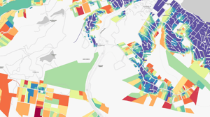
01Explore the Map
Explore the interactive map featuring two layers: the Bushfire Community Exposure Index and the Bushfire Hazard Severity Index.
View Page
Download
02Read the Report
Explore key details of the project, methodology, and critical findings in the 2022-2023 Greater Hobart Bushfire Exposure Index Report.
Download
Read More
03Understand the Index
Discover the Index's benefits, applications, and the construction of the Exposure and Hazard Severity Indices.
Read More
Read More
04Take Action
Empower yourself with knowledge and resources in the 'Taking Action' section to understand and mitigate your bushfire exposure effectively.
Read More